A Rain Forest??
Our trip to the forest was uneventful, although the GPS system took us via the "scenic" route. A key connecting road was not shown on the GPS map; Google did not have it either. Once we found one of the signs erected by the Forest Service, we had no trouble finding the visitor center.
The gateway to the forest is the visitor center, which they call El Portal Rain Forest Center. It is a beautiful, airy building – somewhat like a science fiction cathedral – that contains exhibits and a short movie that introduce and explain the rain forest.
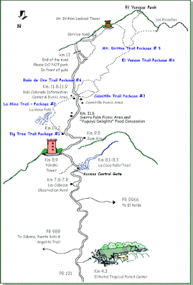
From the visitor center there is a road that climbs almost to the top of El Yunque Peak. From the end of the road, a trail climbs to the top. As shown in the Forest Service map below, there are many other hiking trails available.
We chose two spots to explore: La Coca Falls and La Mina Falls.
La Coca Falls is on the right side of the road as you drive up. It seems like everyone stops there, making it very corwded.
La Mina Falls, located on the left side of the road, is a distance from the road and is accessible by two trails. It is a much bigger falls, with a large basin at the bottom. When we were there, the basin was full of people. We hiked in from the lower trail and when we left, we hiked the upper trail.
I am sure I have more photographs from the hikes. I just have to find which camera I used!
Labels: El Yunque, El Yunque National Forest, El Yunque rain forest, National Forest Service, USDA


0 Comments:
Post a Comment
<< Home